Pre-colonial people of the Knysna forests

Who lived in the Knysna forests before colonial exploitation of the timber began in the late 1700s?
Plentiful evidence exists for the presence of humans in the Knysna area going back to the Earlier Stone Age (see - ‘An Earlier Stone Age site exposed by fire reveals evidence that people have lived in Knysna for well over 300,000 years’ - ‘Knysna’s [90,000 year old] fossil hominin footprints’ - and - ‘Middle Stone Age archaeology in Knysna’), but the question of whether anyone lived permanently in the Knysna forests, and systematically harvested their resources, isn’t easily answered.
Local experts such as Professor Emeritus at UNISA, Michael de Jongh, author of ‘A Forgotten First People: The Southern Cape Hessequa’(amongst others), and conservationists like the Garden Route National Park’s GIS and planning scientist, Johan Baard, point out that the forest environment is neither a pleasant place for people to live in, nor conducive to the needs of either the hunter-gatherers or the herders who populated the region before the arrival of the colonists.
Besides the fact that the forests are cold, damp, and dark, they are also relatively scarce in the edible resources necessary to sustain human communities and (in the case of herders) domestic animals.
This is not to say that humans didn’t utilise the forests in any way: indeed, there’s considerable evidence - including ancient rock art - for a human presence in the world of the trees. But, given the nature of that evidence, it seems that humans tended to pass through the forests on their way to or from the interior, or to enter them from time to time when they needed to, rather than dwelling in them indefinitely.
Caves, shelters, and middens in the Lakes Area of the Southern Cape
To understand the story of early human presence in the Knysna Forests, this article will look at the nature, contents, age, and physical positions of some of the caves, shelters, and middens that have been explored in the Lakes Area of the Southern Cape (Wilderness/Sedgefield/Knysna/Plettenberg Bay), and also in the neighbouring Tsitsikamma Forests.
Cave art in the Southern Cape’s Garden Route
- Please see footnote below: ‘Ethnonyms, community and collective names’
Rock art - of the kind found in our area - is directly related to the medicine or trance dance of Bushmen hunter-gatherers.
Trance dance is "the central religious rite" in which practitioners "harness supernatural potency to enter the spirit world. In the spirit world they believed that they performed various important tasks. These included healing the sick, controlling the weather, visiting far-off places and controlling the movements of game. A number of common dance postures are frequently depicted in the paintings: bending forward at the waist (sometimes supported by dancing sticks), having the arms held out backwards, bleeding from the nose and the related hand-to-nose posture. In addition, certain items specifically associated with the dance are often painted, most commonly dance rattles and fly-whisks. These images all clearly relate the paintings to the trance dance. Much of the imagery goes beyond the dance itself, and depicts the experiences and actions of shamans in the spirit world.” - Rock Art Research Institute
According to information supplied by the Garden Route National Park (SANParks 2017), rock art has been found in shelters in the forests at Bergplaas near Wilderness (along the ridge that separates the Touw River from the Diep River), in the Goudveld-Gouna area near Knysna (in caves usually about 5 metres above the level of the Knysna River), and - in the fynbos in the Tsitsikamma Mountains - at Whitcher’s Cave, north of Storms River Village.
These shelters are all situated within relatively short (up to 2km) distances from walkable access routes running from the coast inland to the Langkloof valley north of the Outeniqua Mountains.
Such routes would probably have followed long-established animal paths - particularly elephant paths - through the Knysna forests.
Interestingly, Prof. de Jongh associates these routes with the Outeniqua people - the ‘People of the Honey’ - after whom the Garden Route was once named, ‘Outeniqualand.’
Outeniqua women were known for carrying honey on their backs over great distances. According to the botanist Carl Peter Thunberg, they accessed the hives using ropes made from the bark of a vine he called Anthyllis (most likely gonna - Passerina spp.). They had “the art of making ropes, by means of which they ascend trees, as by a ladder, when they want to get honey out of them. For this purpose, they first tie a noose round the trunk, in which they put one foot, then they fasten another noose higher up, and when mounted in that untie the former, and so on.” (Thunberg 1793/1986)
Most of the paintings or pictographs found in local shelters are consistent with the ‘fine-line’ style of human-like and animal figures painted with sticks or brushes associated with hunter-gatherers (Bushmen), rather than with the finger-painting style associated with herders (Khoekhoen) - who entered the Southern Cape later than the Bushmen, and whose work is generally characterised by repetitive marks or ‘entoptic phenomena’ (described by the researcher David Lewis-Williams as “visual patterns such as dots, zagging lines… grid patterns” -Wikipedia).
Although herders arrived in the Garden Route around 2,000 years ago - which could have created potential conflict with hunter-gatherers who were already present in the region - the absence of entoptic phenomena in local rock art may or may not be significant. It may simply be that we haven’t found any, since painted rock art on the Indian Ocean side of the Outeniqua Mountains is generally poorly preserved as a result of the higher humidity and rainfall in this area than in the Langkloof and the semi-arid Klein Karoo to the north, where far greater numbers of paintings are known to exist.
Links: Rock art in the Garden Route - images on The African Rock Art Digital Archive
Territoriality: the Matjes River and Klasies River Caves
In a talk to the van Plettenberg Historical Society entitled ‘New ideas about old caves,’ (15 May 2011) Prof. Judith Sealy, Research Chair in Archaeology and Paleoenvironmental Studies and director of the Stable Light Isotope Lab in the Department of Archaeology at University of Cape Town, described how two well-known shelters in Plettenberg Bay provide glimpses into the different life-styles of separate groups of hunter-gatherers who lived in the area in the period 4,500 to 2,000 years ago.
“We ... know, from the bone chemistry of human skeletons found at Matjes River and on the Robberg Peninsula [both of which revealed ritual burials], that between 4,500 and 2,000 years ago, different groups of people with different ways of life lived on either side of the Keurbooms-Bitou estuary.”
The people who inhabited the Matjes River Rock Shelter, east of Keurboomstrand, ate a mixed diet largely made up of plant foods and meat from terrestrial animals, while those who lived in the Guanogat Cave near The Gap on the Robberg Peninsula - 18 km along the beach to the west - specialised in marine foods such as fish, seals, and seabirds.
This is intriguing since both shelters are found close to the beach - but the Matjes River Shelter is situated within a few hundred metres of evergreen Afro-montane forest (Knysna forest), while the Robberg Peninsula is vegetated by fynbos (Cape macchia).
The midden in the Guanogat Cave, “is packed full of shells, fish bone, estuarine grass (Zostera sp.) brought into the site for use as mattresses and cushions, as well as rarer finds such as mammal bone, stone artefacts, bone and ostrich egg-shell beads and other items...
“We also found stone artefacts, and items fashioned from bone, shell and even ivory.”
Prof. Sealy noted that there is much less evidence for occupation of caves on Robberg after 2,000 years ago.
“In fact, all along the southern and western coastlines of South Africa, people harvested marine foods much less intensively after 2000 years ago. This was just part of the disruption of old ways of life as the first domesticated sheep and cattle were brought into South Africa, and people turned from hunting and gathering to sheep- and later cattle-herding. Robberg is clearly not an ideal environment for these activities, and early herders would have gravitated towards grassier environments.”
The intriguing FitzSimons expeditions
F.W. FitzSimons, Director of the Port Elizabeth Museum from 1906 to 1936, believed (in his words) that he had explored “all the known rock dwellings from Coldstream to Groot River” on various expeditions to the Lottering Forest/Harrison Forest/Witteklip Forest area east of the Bloukrans River and west of the Storms River.
His finds included a shelter that he described in articles published in the Illustrated London News in 1921, and in a scientific journal in 1923, as ‘The Tzitzikamma Cave.’
Material recovered from this shelter included at least 23 human skeletons, but FitzSimons failed to properly record the position of the cave, which made it difficult for later students to study these remains in context. Various investigators have tried to pinpoint its position - including G.A. Robinson, a senior member of the staff of the Tsitsikamma Section of the Garden Route National Park (Robinson 1977).
Significantly for the present discussion, “Shellfish appeared not to have been the sole diets of the inhabitants of the cave. Although, as in other coastal sites such as Matjes River and Oakhurst, there was a preponderance of shells, the midden also consisted of a number of animal bones, which lent support to the theory that the inhabitants of the cave were in the habit of hunting in the surrounding forests.” (Schauder 1963)
Schauder reports, too, that “During the course of his investigations of this cave, FitzSimons made a number of valuable observations concerning Strandlooper burials. The doubled-up position with knees drawn up to the chest has since become well known as typical of this area.
“However, in the same cave he came across a type of burial which may have been unique in this region. A complete skeleton reposed in a tomb lined with flat stones. The tomb also contained a variety of artefacts.”
The age of the burials is not given in any of the references cited here, but FitzSimons sent the remains of five of the older skeletons to Raymond Dart, an anthropologist and anatomist in the Department of Anatomy at the University of the Witwatersrand.
Dart later wrote in that, “they afford definite evidence that they belong to the same race as was found in the Transvaal in 1913.” He was referring to ‘Boskop Man’ - a series of finds once thought of as belonging to a separate species, but now considered to be members of our own species, Homo sapiens, dating from the Middle Stone Age.
In all, FitzSimons investigated nine shelters in the region: one inland (Whitcher’s Cave - see below) and eight close to the coast, including the important Lottering River Mouth Cave, whose midden “spreads down the hillside, covered by forest growth. The deposit consists of bone, chipped pebbles and sea-shells such as black mussel, sand mussel, limpet (patella) periwinkle, alikreukel, turbo and whelk… It is recorded that thirteen skeletons and a considerable number of implements were found during the excavation.” (Turner 1970)
Whitcher’s Cave
The investigation of Whitcher’s Cave is considered the most significant of all FitzSimons’ expeditions.
Named for a Mr. Whitcher, who founded the nearby village of Coldstream, and who brought the cave to FitzSimons’ attention, this large shelter - 15 metres wide, 30 m deep, about 10 m high - is situated about 19 km from the coast on a tributary of the Elandsbos River, and at an elevation of about 600 metres in the fynbos-covered Tsitsikamma Mountains.
Whitcher’s Cave contained a “compact layer of midden 10 ft [3.4 m] thick at the mouth and sloping towards the back where it averaged 8 ft [2.4 m] deep. The midden consisted of wood ash, sea shells, bones, pottery, and many waste flakes.” FitzSimons recorded that, “there was an overspill stretching 50 yds [46 m] down the mountainside. More than 50 skeletons were found here.” (Turner, 1970)
Whitcher’s Cave also houses a number of rock art paintings - see accompanying gallery images, published courtesy of SANParks.
Noetzie midden
This open-air midden at the base of a forested hillside near the western end of Knysna's Noetzie Beach, and lying at a height of between five and eight metres above sea level, was excavated by the Archaeology Contracts Office of the University of Cape Town in 2006-2007. It contained two human burials, one of which was dated to about 2,500 years ago. “A woman approximately 40 years old. She was buried on her side in the fully flexed position typical of San burials, with her head pointed to the south. A rock had been placed above her head and ochre staining on the skull and surrounding material suggests application of the red pigment at the time of burial. The grave was a small pit of about 600 mm by 900 mm and only some 400 mm deep.” (Orton 2007)
The site, which was first used somewhere between 3,500 and 4,000 years ago, also revealed cultural material such as stone tools, grindstones, fragments of pottery, ostrich eggshell and other beads, fragments of ochre, and at least one large hearth made of stones brought onto the site from elsewhere.
174 of the ostrich shell beads were found in the burial place.
The Noetzie site revealed that the people who lived here ate fish, seafood, seals, and “bovids of various sizes.” (The bovids, or cloven-hoofed ruminants, include buck such as those that occur in the Garden Route: bushbuck, grey rhebok, grysbok, etc.)
The Noetzie midden provided “a rare opportunity to obtain Later Stone Age material from an open context on the south coast,” which allows for comparison with material found in the many caves of the area. The number of similarities leads to the possible conclusion that open air sites may have been more than just shell processing sites, but rather places of longer-term occupation and activity.
The Knysna Scapula: one of a kind
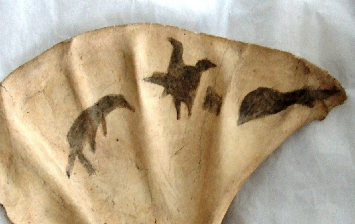
An unusual artefact now resting in the British Museum, the Knysna scapula is a bone decorated with four animal-like paintings: “From the left, the first could well be a seal, the second a bird and the fourth perhaps a fish, but clearly there could be other interpretations.” (Leggatt 2010)
The piece was found in a cave on the Eastern Head by the road engineer, Thomas Bain, who built the Seven Passes Road between George and Knysna over a fifteen year period beginning 1867.
Bain believed the bone was a lion’s, but it clearly wasn’t: experts would later agree that it’s the shoulder blade of a seal. However, it is “the only painting on bone so far found in South Africa (Willcox 1963, Sealy 2006).” (Leggatt 2010)
- Image courtesy Hugo Leggatt
Connecting the past to the present: plant communities at archaeological sites
“The distribution of plants in the landscape has been a major determinant of where archaeological sites occur.” (Deacon 1993, quoted in van Wijk 2017).
We’ve seen that people passed through the forests only lightly in the pre-colonial period, and that the humidity on the ocean-side of the Outeniqua and Tsitsikamma Mountains speeds up the rate of decay of rock art in this area - both of which make finding evidence of human occupation more challenging in the forested Southern Cape than in other, drier areas of the country.
However, new developments in the field of archaeobotany may help future researchers find old sites, since we now know that habitable shelters are often found in association with specific groups of plants used in the medicinal practices of the people who lived in those places.
Traditionally, archaeobotany (or palaeoethnobotany) focussed on “the study of preserved plant evidence from archaeological sites and the reconstruction and interpretation of past human-plant relationships” (Encyclopaedia of Global Archaeology), but for her recent doctoral thesis, ‘Plants, People, and Place: Co-evolving Global Patterns Through Time,’ Dr. Yvette van Wijk studied and analysed the living plants growing at Middle and Later Stone Age sites: “the suite of distinctive plant taxa which persist in small patches of vegetation, often forming dense ‘green walls,’ growing in close association with archaeological habitation and presence sites in the southern Cape.” (van Wijk 2017)
But Dr. van Wijk’s study went further: she also looked at how the same plants are used in the medicinal practices of “self-identifying modern Khoi-San descendants in the southern Cape.”
In seeking to establish links between people, plants, and place; by investigating “the processes which could have resulted in the vegetation pattern found at so many archaeological sites in the Southern Cape;” by looking at how the interactions between people, plants, and place resulted in the persistence of “distinct plant communities over 1000’s of years;” and by examining the possibility that humans were, “agents in the origin of these vegetation communities so closely associated with sites in the past and today,” Dr. van Wijk concluded that, “close synergistic and mutualistic links between important places, plants, and people, have shaped our natural environment going back into deep time."
She thus believes that her research, “can illuminate ways to deal with our present exploitative and destructive lifeways.”
Conclusion: Land of Smoke and Fire
“In many places I observed the land to have been set on fire for the purpose of clearing it... Divers plains here, produce a very high sort of grass, which being of too coarse a nature, and unfit food for cattle, is not consumed, and thus prevents fresh verdure from shooting up; not to mention that it harbours a great number of serpents and beasts of prey. Such a piece of land as this, therefore, is set on fire, to the end that new grass may spring up from the roots.” (Thunberg 1793)
Evidence of human activity in the Knysna forest and neighbouring fynbos - including stone tools, ancient paintings on the walls off rock shelters, and the veld fires reported by so many early European explorers from the 17th Century onwards - reveals that the forested area between George in the west and the Tsitsikamma in the east has been an important cradle of human culture since before our species, Homo sapiens, existed.
The forests reveal their secrets only slowly, though, and exciting research currently underway in fields as diverse (but as interconnected) as archaeology, botany, ethnobotany, and many more, is bound to teach us even more about the human condition, and about our response to things like, for example, climate change and our relationship to the land.
And our relationships with each other.
Author
This article was written by Martin Hatchuel for the Knysna Museum with the help of these fine people:
- Johan Baard (SANParks)
- Theo Stehle (forestry officer, retired)
- Professor Emeritus Michael de Jongh (UNISA)
- Guy Thesen (fine artist, researcher)
- Hugo Leggatt (researcher)
Thank you all!
Further reading
Slavery and labour in the Knysna forests in the 19th Century
Labour in the Knysna forests under apartheid
Footnote: Ethnonyms, community and collective names
The issue of naming communities remains a difficult one for many, and especially for people affected by the lived reality of our past.
Except in the case of direct quotes from other authors, this article follows the advice of the anthropologist, Prof. Michael de Jongh, who has worked with and studied many of the people mentioned here, and who believes that, “we need to be more sensitive to how people self-identify,” rather than following, “terminology that scientists and politicians feel comfortable with.” (de Jongh personal communication)
Prof. de Jongh noted that a decade ago, geneticists tended to favour the terms ‘San’ for hunter-gatherers, and ‘Khoe’ for pastoralists.
However, he states in his email that, until recently, geneticists hadn’t, “intensively interacted with or studied the people they sampled - so terminology-wise they functioned 'top-down'.”
In his work, on the other hand, Prof. de Jongh preferred first to develop rapport with the groups he studied, and to get to know them “as people, not just samples.”
He wrote that the term 'San' is unacceptable to many members of such communities, except to some of their leaders - several of whom he believed to be “not legitimate, but 'fly-by-night' opportunists.”
“They have mostly never heard of it and do not know what it means.”
Recognising that the term Bushmen (for hunter-gatherers) “stems from the early Dutch ‘Boschjesmanne’ - 'people from the bush’,” he pointed out that “the Bushmen have never referred to themselves as 'San’,” which is “an appellation given by the Khoekhoen” (the herders).
He added that the term “'Khoe' used by itself means chauvinistically, ‘man,’ and 'Khoekhoen' means ‘eminent people’,” that “'KoeSan' is a non-word which would mean 'herders without cattle'!” and that “'Khoisan' was popularized by a German zoologist in 1902 to refer to two distinct 'races'.”
Select bibliography
- Anon.: ‘The Precolonial Rise of Khoisan Economies’ in thejournalist.org.za, 29 May, 2018
- Deacon, H.J. & Deacon, Janette: ‘Human beginnings in South Africa’ - David Philip Publishers, Cape Town, 1999
- de Jongh, M.: ‘Roots and Routes: Karretjie People of the Great Karoo’ - UNISA Press, Pretoria, 2013
- de Jongh, M: ‘A Forgotten First People: The Southern Cape Hessequa’ - The Watermark Press, Plettenberg Bay, 2016
- Keller, H.: ‘The subsistence strategies of Middle and Later Stone Age foragers during interstadial/glacial transitions at Knysna, South Africa’ - Thesis for M.A. Anthropology, Yale University, May 2019
- Leggatt, H: ‘Bone art: The Knysna Scapula’ - in The Digging Stick Vol 27(1), South African Archaeological Society, April 2010
- Orton, J. & Halkett, D.: ‘Excavations at Noetzie Midden: an open site on the Cape south coast’ - in The Digging Stick Vol 24 (3), South African Archaeological Society, 2007
- Robinson, G.A. ‘The Riddle of FitzSimons’ ‘Tzitzikamma Cave’ - in Koedoe 20: 95-99, 1977
- Schauder, D.E: ‘The Anthropological Work of F. W. FitzSimons in the Eastern Cape’ - South African Archaeological Bulletin Vol. 18, No. 70, Jul., 1963
- South African National Parks (Arendse, C.J., et al): ‘Garden Route National Park: State of Knowledge’ - Unpublished report (2017)
- Thunberg, Carl Peter: ‘Travels at the Cape of Good Hope 1772-1775 (English edition, 1793)’ - van Riebeeck Society, Cape Town, 1986
- Turner, M: ‘A Search for the Tsitsikamma Shelters’ - The South African Archaeological Bulletin Vol. 25, No. 98, South African Archaeological Society DOI: 10.2307/3887954, Sep., 1970
- van Wijk, Y.: ‘Plants, People, and Place: Co-evolving Global Patterns through time’ - Thesis for D. Phil, Rhodes University, 2017
- Van Wijk, Y., Barker, N.P., Cocks, M.: ‘Analysis of plant communities associated with Rock Art and Habitation sites in the Southern Cape’ - Botany Department & ISER, Rhodes University, Grahamstown (undated)


")


")


Share This Page