Geology of the Knysna Basin
A brief introduction to the geology of the Knysna Basin, with a look at how the landscape was formed
Special thanks to Fred van Berkel, geologist (rtd.) for information and diagrammes
The scenery and geomorphology of the Garden Route south of the Outeniqua Mountains formed as a result of - and after - the final stage of the break-up of the supercontinent Gondwana, which took place during the early Cretaceous, about 110 Ma (Ma = million years ago).
Simply put, the Agulhas Plateau slid westwards along a major fracture in the Earth’s crust known as the Agulhas Falkland Fracture Zone (which formed around 90 Ma), and this laid the foundation for the creation of the landscape which we now know as the Garden Route - which, of course, includes the Knysna basin.
Of course, the actual story’s a bit more complicated than this. So let’s take a look at the ages of the rocks of the Knysna Basin, and then we can have a look at how they all fit together:
Rocks in the Knysna area
The rocks of the Knysna Basin and surrounding areas belong to the following categories*:
- Kaaimans Group – metamorphic rocks (schist, phyllite, quartzite and minor limestone)
- Cape Granite which intruded the Kaaimans rocks
- Cape Supergroup – fluvial and marine sediments (sandstone and shale)
- Table Mountain Group – mainly sandstone
- Bokkeveld Group – alternating sandstone and shale
- Uitenhage Group
- Enon – red-stained conglomerate and minor shales
- Kirkwood - sandstones
- Grahamstown Formation – remnants of the African Erosion Surface (i.e. duricrusts composed of silcrete and/or ferricrete)
- Algoa Formation – wind-blown dune fields and shallow marine sediments
*The geologist’s convention when discussing the stratigraphy - the order in which rocks were formed - is to begin with the oldest and work up to the youngest.
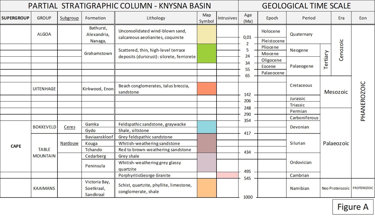 FIGURE A: A partial geological stratigraphic column on the rocks of the Knysna Basin
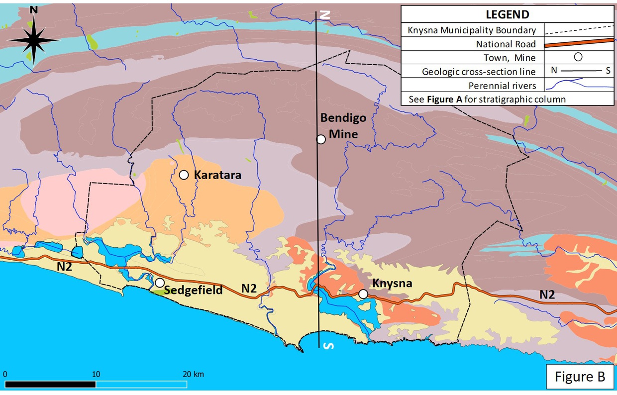 FIGURE B: Geology of the Knysna area
- Cross section N-S on Longitude 23o East: see FIGURE C below
- Visit Gold mining: Knysna's Millwood gold fields for the story of Knysna’s gold rush; and
- Visit this page for information about how the gold was formed.
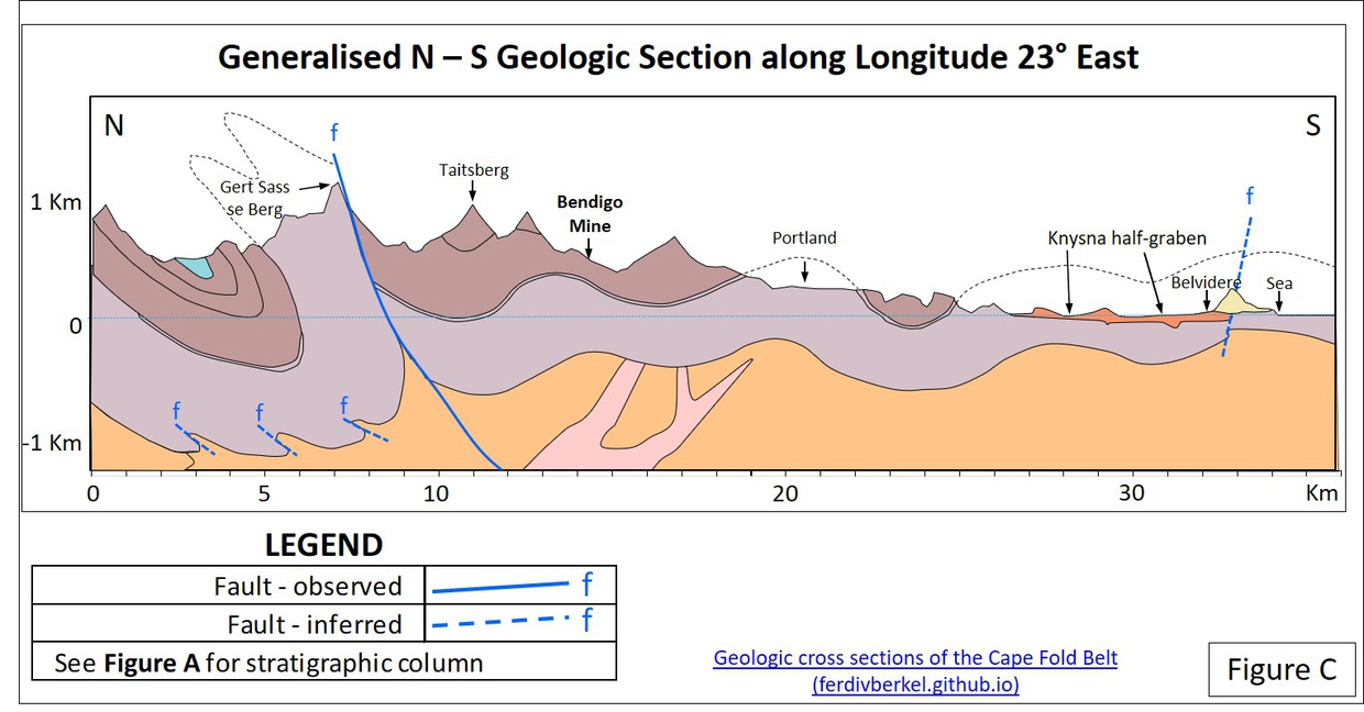 FIGURE C: A simplified cross-section along section line N-S (in Figure B) showing individual rock Formations. Source: F van Berkel, Geologic cross sections of the Cape Fold Belt
Ages of the rocks underlying the Knysna Basin
Please refer to Figure A
- The rocks found in the Knysna area range in age from pre-Cambrian (~700 Ma) to the late Pleistocene (about 90,000years ago)
- Geological units in the Knysna area are subdivided into the Kaaimans-Kango basement (the oldest rocks), with younger cover rocks made up of a thick sedimentary pile overlying this basement.
- These younger cover rocks belong to the Ordovician- to Devonian-age Cape Supergroup (about 500 Ma to 350 Ma)
- Along the coast, younger Uitenhage Group sediments occur in narrow basin structures that formed during the break-up of the supercontinent Gondwana in the late Jurassic- to early Cretaceous Periods. (110 Ma to 90 Ma)
- The coastal plains are covered by a thin veneer of shallow marine and aeolian (wind-blown) sediment that belong to the Algoa Group (2 Ma and less).
The Cape Fold Belt
The Knysna basin is fringed to the north by the Outeniqua Mountains, which form part of the Cape Fold Belt, which was formed in the Permo-Triassic age (289 - 230 Ma).
At 1,565 meters above sea level, Cradock Peak is the highest mountain in the Outeniquas - but when they were at their highest (in the late Permian, around 258 Ma), these mountains would have thrust up to as much as six- to seven km above current sea level.
The Agulhas Falkland Fracture
Although the folding in the Outeniquas occurred in the Permo-Triassic age (289 - 230 Ma), the scenery and geomorphology of the terrain south of the Outeniquas formed as a result of and subsequent to the final stage of the break-up of Gondwana during the early Cretaceous (about 110 Ma).
During this period, the Agulhas Plateau slid westwards along the major crustal fracture known the Agulhas Falkland Fracture Zone (Figure D).
- 145 Ma: The supercontinent Gondwana began breaking up along our east coast, with South America drifting westwards, and the Proto-Atlantic Ocean forming between it and the African landmass
- 125 MA: Gondwana began breaking up along our west coast, with East Antarctica moving eastwards to form the Proto-Indian Ocean
- 110 MA: Gondwana began breaking up along the Agulhas Falkland Fracture Zone, forming the graben structures which would later fill with Uitenhage sediments as discussed above.
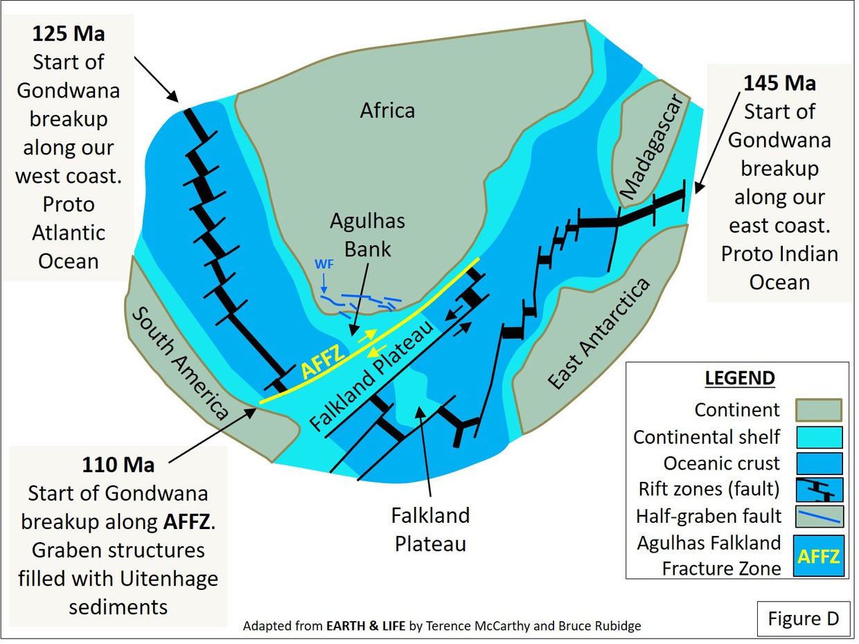
FIGURE D: The Agulhas Falkland Fracture (AFFZ)
The enormous frictional forces of two thick crustal plates sliding and grinding past one other stretched the Earth’s crust along the coastal region of what is now South Africa. This resulted in the formation of numerous crustal fracture zones in a northwest- to southeast orientation along our coastline.
Small graben and half-graben structures
Inland, these extensional forces resulted in the formation of major fault zones that lie in a west-east direction, with small graben and half-graben structures (down-thrown blocks) forming on the south sides of the faults.
- A graben is “a depressed block of the crust of a planet bordered by parallel faults.” - Wikipedia
- A half-graben is “a geological structure bounded by a fault along one side of its boundaries, unlike a full graben where a depressed block of land is bordered by parallel faults.” - Wikipedia
- Note: Local earth tremors. Occasional tremors experienced in the southern portion of the Cape Province are caused by the release of stress that builds up on these inland east-west faults. The last big earthquake occurred in 1969 on the Worcester Fault in the Tulbagh area.
During the wet tropical climate regime prevalent in the early Cretaceous (145 – 125 Ma), Uitenhage Group sediments filled the offshore Outeniqua Basin with a mixture of marine sediments and terrestrial sediments derived from the erosion of the Outeniqua Mountains. These sediments reach a thickness of up to 8 km in places and are today a source of natural gas. Onshore, Uitenhage Group terrestrial sediments (Enon and Kirkwood Formations) filled fault-bound basins which formed valleys that drained the mountain ranges of the Cape Fold Belt.
It is speculated that the Knysna basin is underlain by a shallow northwest-southeast trending half-graben structure filled with Enon conglomerates belonging to the lowermost member of the Uitenhage Group (see Figure C). Spectacular outcrops of Enon conglomerates, sandstones and siltstones can be seen in the red cliffs along the N2 (lagoon road) between the White Bridge and Knysna, with similar outcrops along the road from the White Bridge to Brenton-on-Sea (between Knysna Chalets and Pembreys Restaurant), and along the Phantom Pass road north of the White Bridge.
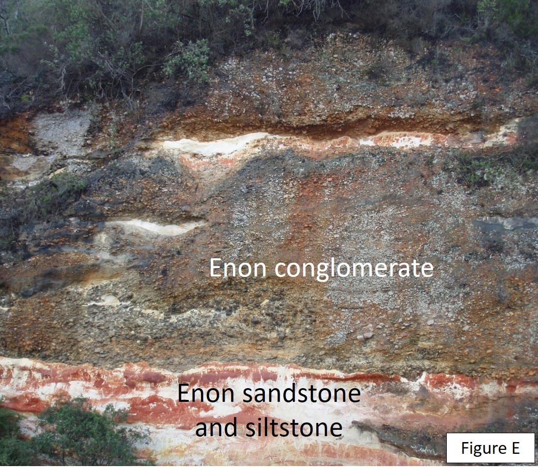 Figure E: Enon conglomerate, sandstones and siltstones exposed in the cliffs along the N2 highway (Lagoon Road)
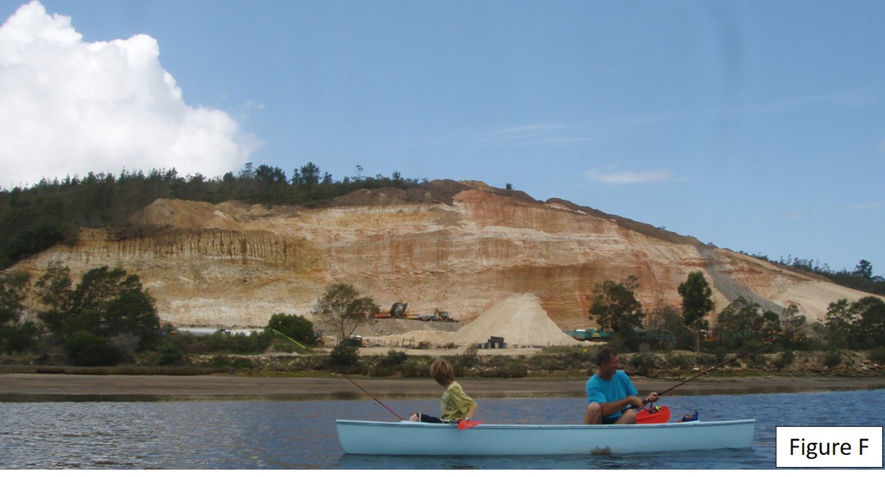 Figure F: Enon quarry – eastern shore of Knysna Estuary during widening of N2 highway (Lagoon Road) in 2010
The coastal plain
Our coast was lifted by some 300 metres in the period from about the early Palaeocene (60 Ma) to the mid Miocene (20 Ma), exposing the continental shelf to erosion. This exposed shelf is commonly known locally as the coastal plain, or the wave-cut platform. (See Google Maps - Figure G below)
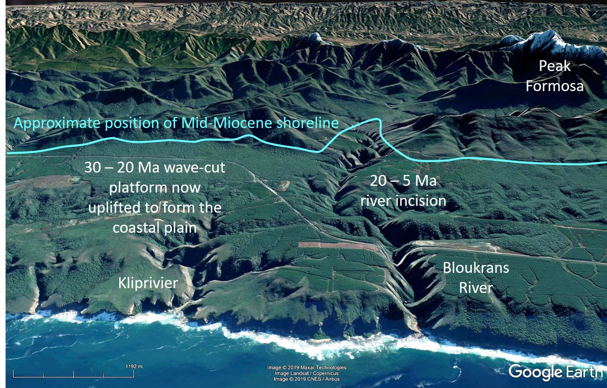
Figure G: The coastal plain
This uplift rejuvenated the erosion cycle, resulting in the deep incision of the rivers draining the Outeniquas during a wet-climate cycle, and removing the bulk of the Enon conglomerate that formed the valley fill.
Our coast uplifted a further 200 metres - causing yet further deep incision of the coastal plain - during the Pliocene (8 Ma).
Sea level changes influenced the formation of present-day rivers
Landscape features that formed from the end of the Pliocene (2 Ma) to the present day are driven by climatic and glacio-eustatic sea-level movements caused by the onset of glacial and interglacial conditions in the northern hemisphere. (Glacio-eustasy: changes in sea level due to the uptake or release of water from glaciers and polar ice.)
Sea levels dropped several times by up to 120 m below present-day during glacial periods in the late Pleistocene. When the coastline was located about 90 km south of its current position, large sand-covered tracts of the continental shelf were exposed to wind erosion. The lower portions of today’s coastal rivers were incised during these low sea level stands.
The channels thus formed, and now preserved on the continental shelf, were partially filled again with alluvial and estuarine sediments during subsequent periods of high sea levels that were associated with global warming.
Marine benches and sea caves found in today’s coastal cliffs formed during lengthy periods of sea level still-stand, which ocured during the overall decline in sea level that took place during the Late Pliocene Interglaicial (130,000 - 120,000 Years Before Present) and the Holocene Interglacial (which started around 11,000 YBP) .
As a result of the glacial periods of the late Pleistocene, our coastline moved to-and-fro by up to 120 km seawards. This movement exposed vast areas of sand-covered continental shelf to wind erosion. Extensive dune fields formed on the shelf and along our coast during these cold and dry times.
The Knysna Heads
- Please see our page Geomorphology: How the Knysna Heads were formed
Plate tectonics
Watch the video below for a longer look at the phenomenon of plate tectonics, or watch from 4:10 for a look at the last 140 million years. You'll clearly see how the landmasses pulled apart to form the geography of the Garden Route as we know it today.
Conventions, spelling, etc:
- Glossary of Geology, Fifth Edition (revised) by Klaus K.E. Neuendorf, James P. Mehl Jr., Julia A. Jackson. American Geosciences Institute, 2011
Article authors: Martin Hatchuel and Fred van Berkel (geologist, retd.)


")


")


Share This Page